
Droog warm weer heeft deze lente gezorgd voor bosbranden in Siberië. ESA’s Sentinel-satellieten werken samen om de ontwikkelingen in kaart te brengen. SRON-wetenschappers leveren de data voor de uitstoot van koolstofmonoxide met het TROPOMI-instrument op Sentinel-5P.
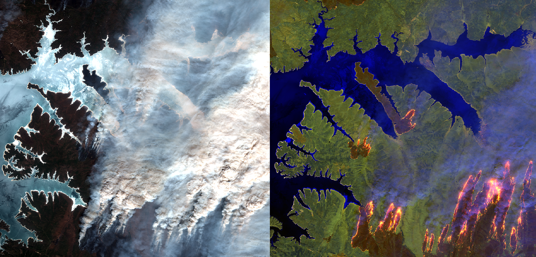
Het noordelijke deel van de Aarde warmt sneller op dan de rest van de planeet. De hitte droogt de bossen uit zodat ze sneller in brand vliegen. Op 9 mei sloegen bosbranden wild om zich heen in het verre oosten van Rusland rond de stad Komsomolsk-on-Amur. De Sibarian Times publiceerde beelden van vlammen die wegen, velden en bossen verslinden.
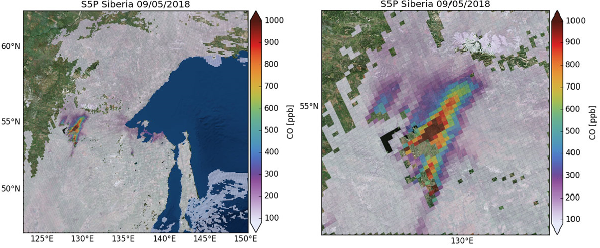
ESA’s Sentinel-satellieten voeden de informatiediensten van het EU Copernicusprogramma, zoals een kaart die live bosbranden weergeeft van over de hele wereld. De missies stoelen op verschillende technieken, zoals radar en multispectrale apparatuur, om land, oceaan en atmosfeer in de gaten te houden. Sentinel-5P monitort de atmosfeer met haar TROPOspheric Monitoring Instrument (TROPOMI)—een samenwerking tussen Nederland en ESA. Onderstaande afbeeldingen tonen TROPOMI’s koolstofmonoxidemetingen van een bosbrand naast het Zeja stuwmeer, verwerkt door SRON-onderzoekers Tobias Borsdorff en Jochen Landgraf, met een resolutie van minder dan vijftig vierkante kilometer.
Over TROPOMI
Tropomi is een samenwerking tussen Airbus Defence and Space Netherlands, KNMI, SRON en TNO, in opdracht van het NSO en ESA. De wetenschappelijke leiding is in handen van het KNMI en SRON. Tropomi wordt gefinancierd door het Ministerie van Economische Zaken, het Ministerie van Onderwijs, Cultuur en Wetenschap en het Ministerie van Infrastructuur en Milieu. Het Tropomi-instrument bevindt zich aan boord van de Europese satelliet Sentinel-5p. De zes Sentinel-satellieten vormen de door ESA ontwikkelde ruimtecomponent van het Copernicus-programma voor aardobservatie van de Europese Commissie.
—————————————————————————————————————————
Sentinel satellites work together to monitor wildfires
Dry, warm weather has sparked wildfires over Siberia this spring. ESA’s Sentinel satellites collaborate to monitor the developments. SRON scientists provide data on carbon monoxide emissions using the TROPOMI instrument on Sentinel 5P.
The northern part of the world is warming faster than the planet as a whole, with heat drying out forests and making them more prone to burn. On the 9th of May, wildfires blazed in Russia’s Far East around Komsomolsk-on-Amur, a city of nearly 264,000. The Siberian Times published images of flames consuming roads, fields and forests.
ESA’s Sentinel satellites provide a unique set of observations, which are fed into a range of thematic information services from the EU Copernicus programme, such as a live world map of wildfires. The missions carry a range of technologies, such as radar and multi-spectral imaging instruments for land, ocean and atmospheric monitoring. Sentinel-5P is dedicated to monitor the Earth’s atmosphere, using the TROPOspheric Monitoring Instrument (TROPOMI)—a collaboration between The Netherlands and ESA. The figures below show TROPOMI’s carbon monoxide measurements of a wildfire close to the Zejareservoir, processed by SRON scientists Tobias Borsdorff and Jochen Landgraf, with a spatial resolution of less than fifty square kilometers.
About TROPOMI
Tropomi is a collaboration between Airbus Defence and Space Netherlands, KNMI, SRON, and TNO, on behalf of the NSO and ESA. The scientific leadership is in the hands of KNMI and SRON. Tropomi is funded by the Ministry of Economic Affairs, the Ministry of Education, Culture and Science, and the Ministry of Infrastructure and the Environment. The instrument is located on board the European satellite Sentinel-5p. The six Sentinel satellites form the space component developed by ESA for the European Commission’s Copernicus program.